Measured Building
BIM
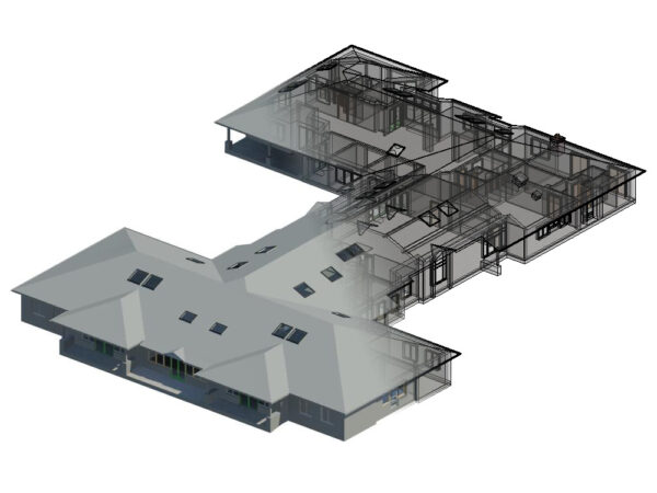
Drawing on extensive experience in measured buildings surveys, LandScope is now able to deploy the latest and fastest laser scanners to rapidly model buildings both internally and externally, creating the basis for traditional drawings or a 3D model as an input to BIM projects.
The laser scanning service is able to deliver fundamental base components to the BIM process including building part geometries and spatial relationships, either in its raw LiDAR point cloud form as a resultant parametric model or similar.

MEASURED BUILDING SURVEY
A measured building survey produces an accurate model of a specific building, both internally and externally, and provides vital data to support architects, building contractors, structural engineers, and facility managers during the life cycle of a building structure. Using the latest technology, detailed and highly sophisticated 3D models are produced from which traditional floor plans, elevations and sections can be generated.
BIM
Building Information Modelling (BIM) is an intelligent 3D model-based process providing project cohesion between architecture, engineering, and construction (AEC) professionals. BIM supplies the toolbox to efficiently plan, design, construct, and manage buildings and infrastructure. We have designed workflows and deliverable outputs to feed directly into the BIM modelling process, through the best available technology and the highest qualified survey professionals to ensure technical certainty.